


EL PASO, Texas (KTSM) — It’s St. Patrick’s Day, and yes, we are under a Weather Authority Alert. Why?
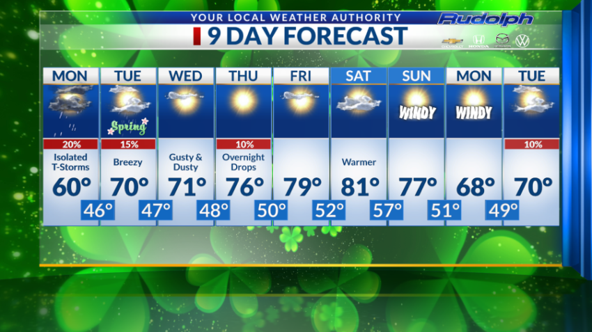
We are forecasting overnight isolated thunderstorms into Monday morning. Wind will also be picking up during the day Monday. We can expect to easterly winds ranging from 20-30 mph. The forecasted high for Monday is predicted to be at 60 degrees with an overnight low of 46 degrees.
So with that being said, bundle up and use this weather as an opportunity to become a Weather Watcher!
Moving on Tuesday. It is the first day of spring after 9:06 p.m. of course. We are forecasting breezy conditions and 25% chance of isolated showers throughout the day. The high jumps to 70 degrees and 47 degrees in the evening.
Just in time for Small Town Spotlight, we are forecasting a gusty and dusty day on Wednesday with our high to sit at 71 degrees. We can expect to cool off to 48 degrees for our overnight low.
Thursday, I’m shooting for 10 percent chance of rain as we are predicting overnight drops. Seventy-six is the forecasted high and our overnight low is at 50.
Ah, yes it’s Friday and a perfect day! We are forecasting a high of 79 degrees with mostly sunny skies. Fifty-two degrees is the overnight low.
Saturday, we are predicting a much warmer day with partly cloudy skies. We will warm up to 81 degrees. It will be an absolutely perfect day to even swim a little and enjoy a picnic.
Windy conditions are forecasted for Sunday and Monday with highs ranging from the upper 70s to upper 60s.
Tuesday we are forecasting 10% chance of rain and a high of 70 degrees.
Have a good week, Sun City!
Read: Read More