


EL PASO, Texas (KTSM) — Happy Saturday, El Paso. We are one day away from Easter and forecasted winds!
Let’s hop right into it, get it?
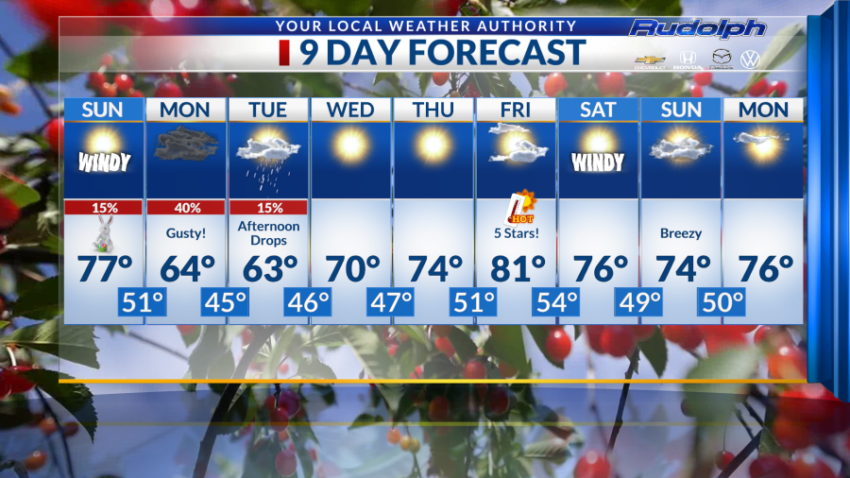
Sunday’s high for the day is forecasted to sit at 77 degrees paired with a very windy afternoon. We can predict gusts to reach up to 40 mph. Fifty-one degrees is the forecasted overnight low with a 15% chance of isolated overnight showers.
Moving to Monday, we are predicting rain to linger into the morning so we are forecasting temperature’s to drop to 64 degrees with 40% chance of scattered showers. That’s paired with strong winds that should diminish to 15 to 20 mph after midnight. Speaking of the evening our overnight low sits at 45 degrees.
Tuesday things lighten up just a tad. We are forecasting a 15% chance of afternoon drops with a high of 63 degrees, with evening temperatures cooling off to 46 degrees.
Sunny skies make a return Wednesday and we expect to warm up to 70 degrees with 47 degree as the overnight low.
Thursday is looking similar. We are forecasting the high to sit at 74 degrees and overnight low at 51 degrees.
Friday! I give this day 5 stars (Because I really love warm weather). We are forecasting broken clouds through out the day and a high of… 81 DEGREES! Our overnight low is predicted to sit at 54 degrees.
Now we can get off our summer haven because Saturday we drop to 76 degrees paired with windy conditions. Evening temperatures sit at 49 degrees.
The remainder of the week’s highs are forecasted to be in the mid 70s and overnight lows at 50 degrees.
Now that you have come this far I would like to say now, I will be out tomorrow to celebrate Easter with my family but we can expect to be on a Weather Authority Alert in preparation for Monday, Tirza Ortiz will be providing you the latest scoop in weather.
See you soon Sun City. Thank you to those who have supported me.
Read: Read More