


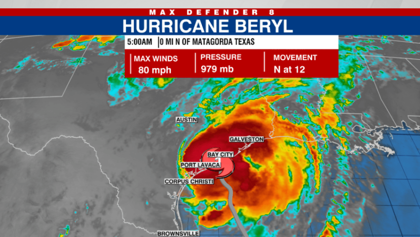
TAMPA, Fla. (WFLA) — Hurricane Beryl made landfall on Texas’ Gulf coast early Monday morning, according to the National Hurricane Center.
At 5 a.m., the hurricane’s center was said to have made landfall as a category one hurricane near Matagorda, Texas — which is about 85 miles west south-southwest of Houston. It was said to be about 40 miles southwest of Houston at 8 a.m.
The hurricane had maximum sustained winds of 75 mph and moved north at 12 mph.
“After landfall, Beryl continues to track north, and storm surge conditions continue along the Texas coastline,” Max Defender 8 meteorologist Leigh Spann said. “The onshore wind helps push water from the Gulf of Mexico farther inland and increasing the threat for flooding.”
The following areas are under a storm surge warning:
Mesquite Bay to Sabine Pass, including Matagorda Bay and Galveston
Bay
The following areas are under a hurricane warning:
The Texas coast from Mesquite Bay northward to Port Bolivar
The following areas are under a tropical storm warning warning:
The Texas coast north of Port Bolivar to Sabine Pass
Beryl is expected to make a turn to the northeast Monday night as it gains speed. The NHC said it will head over east Texas into the Lower Mississippi Valley and the Ohio Valley over the next two days.
The hurricane will lose strength as it moves inland, weakening to a tropical depression by Tuesday.
Rainfall totals are expected to be five to 10 inches with local totals possibly reaching 15 inches of rain.
The NHC said east Texas and the coast could see “considerable flash and urban flooding” as well as river flooding.
Storm surge is also a potential threat, with the following areas possibly seeing the following surge levels:
Port O’Connor, Texas to San Luis Pass, Texas — 4-7 feet
Matagorda Bay — 4-7 feet
San Luis Pass, Texas to High Island, Texas — 4-6 feet
Galveston Bay — 4-6 feet
Mesquite Bay, Texas to Port O’Connor, Texas — 3-5 feet
High Island, Texas to Sabine Pass, Texas — 3-5 feet
However, as the system moves inland, the rain totals are expected to decrease, with the NHC forecasting three to five inches of rain for Oklahoma, Arkansas, and southern Missouri Monday night and Tuesday.
Forecasters also said Texas, Louisiana, and Arkansas may see some tornadoes Monday.
Read: Read More