


El Paso, Texas (KTSM) — It’s another hot day for the Borderland!
Triple digits look like they are back for the weekend. There is also a very slight chance of storms between 3 to 4 p.m. Friday in Central and East El Paso.
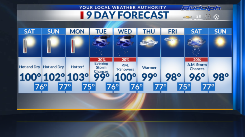
Let’s move over to what we can expect for the weekend and the coming days.
Not much is to change for Saturday, except we won’t see any moisture.
The forecasted high is expected to warm up to 100 degrees paired with hot breezes ranging from 10 to 15 mph. Saturday’s overnight low sits at 76 degrees.
Sunday’s high is to reach 102 degrees with an overnight low of 77 degrees.
Conditions are to remain dry and even hotter than both Friday and Saturday. Winds for Sunday are forecasted to stick between 5-10 mph. This may let us cool off just a tad from the El Paso heat.
Triple digits are in once again in line for Monday, this time warming up to 103 degrees.
It’s extremely critical to take care of yourselves and loved ones when it comes to the hot days in the Borderland.
Proactive ways to protect yourself from heat exhaustion or any heat-related illnesses is to drink water frequently, wear light clothing, take frequent breaks and relax in the shade if you stay outdoors for long periods at a time.
You can also find local cool centers near you by reading the article linked below.
Tuesday is off to a dry and partly cloudy start.
The forecasted high kicks us off that triple-digit streak as we are expected to reach 99 degrees Tuesday. Tuesday evening, we are expected to to dip to 76 degrees with a 30% chance of evening storms before midnight.
Wednesday bring us similar conditions.
We begin the day with clouds paired with humidity in the air. Wednesday’s high is forecasted to reach 100 degrees, nothing yet but weather takes a turn at night. Our overnight cools off to 76 degrees with a 20% chance of storms. These storm chances can make an appearance possibly before midnight and lasting until the about 2 a.m.
Back to double digits we go!
Ninety-nine degrees is the predicted high for Thursday.
Weather conditions consist of partly cloudy skies giving us that very much needed shade. Thursday’s overnight low is a warm temperature of 77 degrees making it a nice night to have an outing and enjoy that El Paso sunset!
Ninety-eight degrees is the expected high for Friday, paired with mostly sunny skies. Nothing major to report for Friday, other than the UV index is expected to peak at around 1 p.m., meaning wear that sunscreen to prevent any unwanted sunburns! Evening temperatures sit at 75 degrees.
Get ready for this: Next Saturday is expected to be the coolest day out of the week.
Saturday is already off to an interesting start as we forecast 20% chance of morning storms. At this time, storm chances remain slim in the morning, but based on the high being a little lower than usual that is expected to change later in the week.
The high is predicted to reach 96 degrees, making it the coolest day of our 9-Day forecast. Our overnight low remains fairly warm at 77 degrees.
Sunny and warm is the weather conditions expected for next Sunday! Ninety-eight degrees is the high paired with very light winds throughout the day. Talk about a perfect day to sit poolside!
That’s your 9-Day forecast.
Read: Read More