


El Paso, Texas (KTSM) — We have seen some significant rainfall on Monday, like I predicted in Sunday’s newscast.
We will continue to see scattered rain throughout the day and into the evening.
Although many people are off and would rather enjoy the day outdoors, the rain was much needed. On the bright side for some, we’re in for much calmer days ahead.
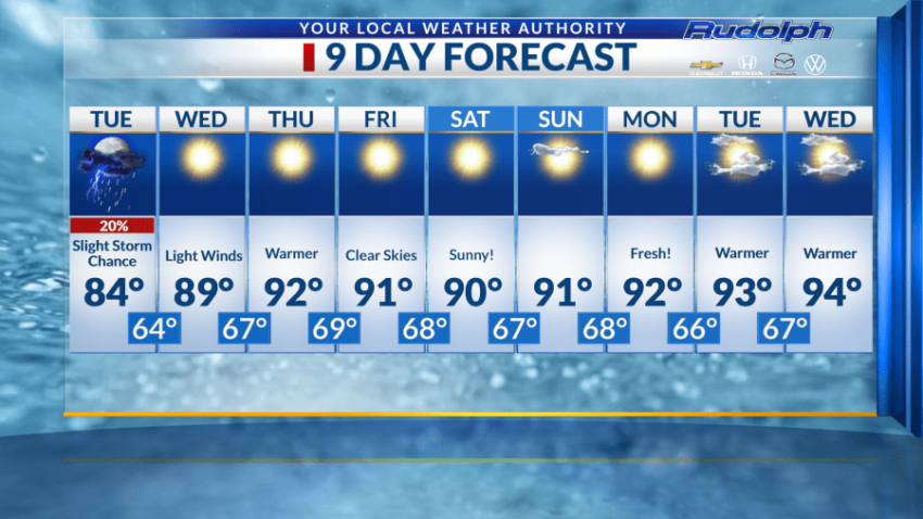
There is a 20% chance we will see storms Tuesday.
During the day, we are predicting our high to reach 84 degrees paired with partly cloud skies. Tuesday night is when we can expect rainfall to begin before midnight. Our overnight low sits at 64 degrees. This is the coolest night in our forecast. You might want to start consider bringing out your warmer apparel if you have evening plans.
Eighty-nine degrees is the forecasted high for Wednesday. There is nothing significant to report for this day.
Sunny skies are taking over and we will gradually start warming up again. Wednesday ends the day with a evening temperature of 67 degrees.
Back to those 90s we go!
Thursday, our predicted high is 92 degrees, once again paired with sunny skies. I hope you’re getting used to the sunny forecast. So far, it looks like it’s here to stay. The day will also consist of light winds ranging from 5 to 10 mph.
Sixty-nine degrees is the forecasted overnight low for Thursday.
Friday’s weather conditions brings us clear skies and a warm temperature of 91 degrees.
You know as I calculate our forecast it makes me wish we could stay in this type of weather. Not too cold, not too hot.
Into the weekend, 90s will continue to make themselves at home.
Saturday kicks off with sunny skies and a forecasted high reaching 90 degrees. Breezy conditions will be a factor for this day, ranging from 10-15 mph.
Sunday’s high can potentially warm up to 91 degrees.
The skies will be mostly clear, as you’ve noticed this 9-Day forecast is rather calm. However, this may be the calm before the storm. Meaning, we may be in for an even cooler cold front!
Monday, the high is also predicted to warm up to 92 degrees. We are progressively getting warmer but we are far away from those triple digits. Monday night, we are forecasted to dip to a temperature of 66 degrees.
All our overnight lows in our forecast are in the 60s!
The remainder of our forecast will continue the warming trend in the 90s paired with some mostly clear skies. No shocker that we can expect to see more clouds during these days as well.
There is only 19 day until fall!
Read: Read More