


TAMPA, Fla. (WFLA) — Hurricane Milton, which has fluctuated between a Category 4 and Category 5 hurricane on its approach to Florida’s west coast, has the potential to cause catastrophic damage upon making landfall.
But where it makes landfall, exactly, will likely make a vast difference in how much damage residents of coastal communities can expect.
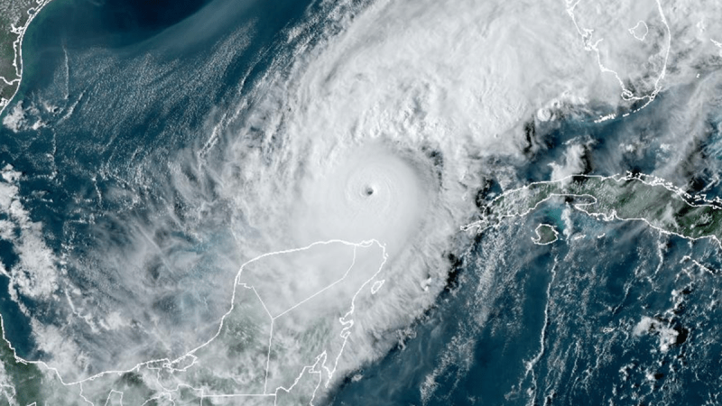
The Wobble Tracker — a tool used by Nexstar’s WFLA to track “wobbles,” or small movements on the system’s path — can help determine where the hurricane is headed in real-time, and potentially how much devastation Floridians can expect.
As of Wednesday, Milton’s eye was tracking to pass just south of Tampa Bay, but changes in its path are likely until the hurricane is just offshore. These slight changes may also produce drastic differences in how the bay is hit by storm surge.
“If it hits St. Pete Beach, there’s 15 feet of water in the Bay,” Jeff Berardelli, WFLA’s chief meteorologist, said this week. “If it hits Longboat Key, 15, 20 miles south of there, there’s not much of any water in the bay.”
“You’re going to have to watch the wobble tracker up until 20 miles off shore,” Berardelli added.
Any change in the forecast concerning Milton’s path, meanwhile, shouldn’t allay any concerns from residents on the coast. Cathie Perkins, the emergency management director in Pinellas County, warned those in Milton’s potential paths that they should still heed all evacuation orders from official agencies.
“Everybody in Tampa Bay should assume we are going to be ground zero,” Perkins said.
Nexstar’s WFLA first launched the wobble tracker for Hurricane Ian, a Category 5 hurricane that was originally expected to make a direct hit on Tampa Bay but “wobbled” further south to its landfall in Charlotte County, Florida.
Since then, the tracker has been a major asset in other major hurricanes like Helene and, now, Milton.
The wobble tracker watches the motion of hurricanes and tropical storms by using a combination of data from satellites, radar, the forecast trajectory, and the previous path the storm is on, to indicate how the path is changing in real time.
The WFLA Wobble Tracker will remain actively streaming 24/7 until Milton makes landfall.
Be prepared with the 2024 Hurricane Guide and stay ahead of tropical development with WFLA’s Tracking the Tropics newsletter.
Read: Read More