


We dropped 6 degrees today to a high of 63. Yesterday’s high was 69. Today, the major problem (mostly for the west side) has been the chilly, gusty winds. At the airport, the peak gust was 27 mph from the east. That’s not too bad on the east side, but the winds pick up strength as they pass over the mountains. The winds get a little better tomorrow as we continue to cool down.
Sunset in the Mesilla Valley from Weather Watcher Virginia Contreras
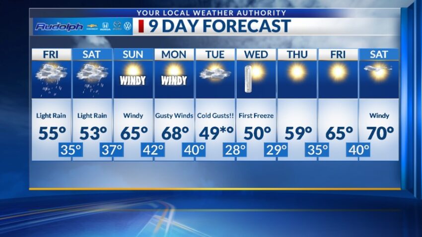
TONIGHT: The skies will turn mostly cloudy overnight with a chance of light rain late evening/overnight. The east winds will range from 15-25 mph, which will translate into stronger gusts on the west slopes of the mountains. The low will drop to 41.
FORECAST: Friday will be mostly cloudy with light rain and chilly winds. With a high of 55, the NE winds will range from 10-20 mph with stronger gusts on the west slopes. Saturday will be cloudy and chilly with a high of 53. Expect more light rain showers before clearing late Saturday night. Sunday will be sunny and windy as the low-pressure system makes its way out of the Borderland. We’ll warm up to 65, and the west winds will gust to near 35 mph. Monday will be mostly sunny and windy with a high of 68. The west-NW winds will range from 15-40 mph. A powerful cold front blows in on Tuesday dropping the high to 49* (which could be a morning high). At this point, the systems looks fairly dry, so we should see partly to mostly cloudy skies. The north winds will feel very cold with gusts near 40 mph. Our first of official freeze at the airport will be Wednesday morning with a low of 28. Wednesday will be sunny with a high of 50. Thursday will be sunny and 59.
Read: Read More