


The official high today is 64. Normal is 61, and the record is 77 set in 1911. We’re likely going to flirt with record warmth next week, but before we get there, we must deal with two days of gusty, chilly winds and a dusty haze. Here’s your exclusive 9 Hour Forecast for Wednesday and your detailed 9 Day Forecast below.

TONIGHT: The skies will be partly to mostly cloudy overnight. The winds will be light and variable at 5-10 mph. The low will drop to 37.
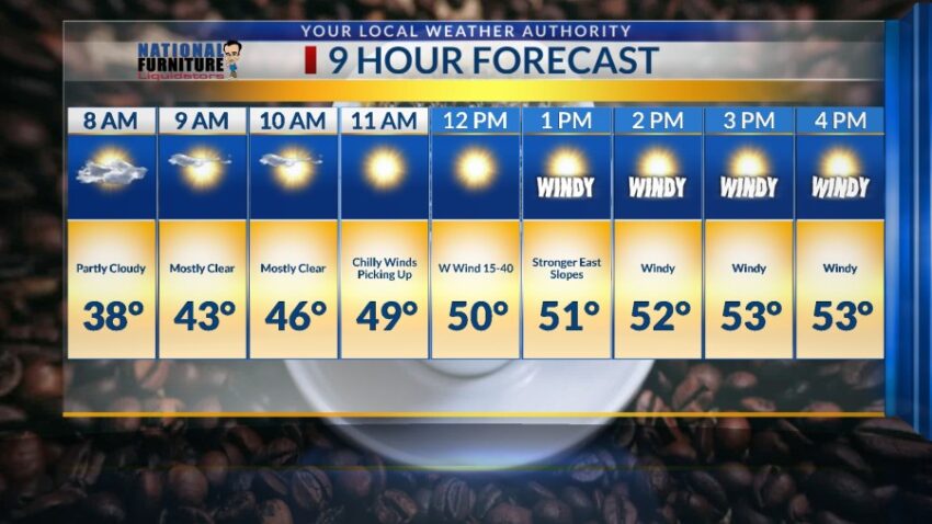
FORECAST: KTSM has issued a Weather Authority Alert due to gusty winds and a noticeable drop in temperatures on both Wednesday and Thursday. Wednesday will be partly cloudy and windy as a Pacific low-pressure system moves over the Borderland stirring up the winds. The winds shift west at 15-40 mph with stronger gusts on the east slopes. The winds will likely stir up a slight dusty haze in the afternoon, and the high will only reach 53. The chilly winds will be stronger on Thursday with a high of 54. The skies will clear, and the NW winds will range from 15-45 mph. Once again, we could see a slight dusty haze on Thursday. Friday will be sunny with light winds and a high of 65. High pressure is about to build up in a dramatic way for the week ahead. Saturday will be sunny and 70. Sunday will be mostly sunny and 76. Monday will be sunny and 78.

Read: Read More