


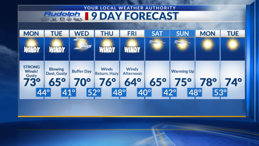
EL PASO, Texas (KTSM) — Happy Sunday, El Paso. As if ending the weekend and going to work on Monday isn’t enough, Mother Nature is bringing strong winds into the equation. We are issuing a Weather Authority Alert due to the high winds most of the Borderland will be experiencing on Monday, especially here in El Paso and Las Cruces.
Expect a high in the low 70s coupled with winds from the southwest blowing from 30-40 mph. Gusts can reach speeds of 55 mph in some areas, with blowing dust highly likely. In addition to a high wind warning, the National Weather Service has also issued a red-flag warning – meaning critical fire weather conditions that are a result of strong winds and low humidity. Both of these warnings will expire by 8 p.m.
Overnight, we’ll see a low around 45 degrees with mostly clear skies. Winds will still prevail, blowing upwards of 35 mph, with wind gusts as high as 50 mph.
Tuesday is only slightly calmer, but about 10 degrees cooler. With a high near 65, blowing dust and gusty conditions are still the focus. Winds will blow from the west at 25-30 mph, with gusts nearing 40 mph. Overnight wind speeds decrease 5-10 mph after midnight, with gusts as high as 30 mph.
Wednesday will serve as a much-needed buffer, with a high near 70 and breezy, calm conditions. Fifty-two will be the low going into Thursday morning where winds increase once again.
Blowing dust will most likely start just before noon with winds anywhere between 10-20 mph, up to 30 mph in the afternoon. Gusts will once again reach near 40 mph as we also see an above-average high around 76 and low around 48.
Friday will have similar conditions, slightly cooler with a high in the lower 60s and low in the lower 40s. Winds will finally calm down just in time for the weekend with a high near 65 anticipated for Saturday, and an even warmer Sunday at around 75.
 Read: Read More