


The morning started out so beautiful today, and then (as expected) all heck broke loose. Powerful winds lifted up the dust and reduced visibility. Soon, those strong winds will turn chilly as the high drops to 59 Saturday. Today’s high was 74, and the peak gust so far at the airport has been 49 mph. Here’s your exclusive 9-Hour Forecast for Saturday:

TONIGHT: KTSM is extending the Weather Authority Alert through Saturday due to powerful winds, blowing dust, and a significant drop in temperatures with a cold front. A Dust Storm Warning is in effect until 6:45 PM. A Wind Advisory and a Dust Advisory are posted until 7 PM. The W-SW winds will gust near 60 mph, and those winds will turn quite chilly overnight. Expect partly to mostly cloudy skies and a chance for a few raindrops. The low will be 42.
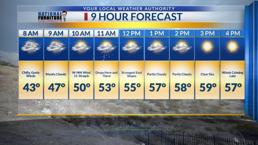
FORECAST: Saturday will be partly to mostly cloudy with a few drops as a cold front blows through. The NW winds will gust near 55 mph, which will cause blowing dust. The high will drop to 59, and the winds will slowly diminish Saturday evening. Sunday will be sunny and beautiful with a high of 66. The winds will be light and variable. Monday will be sunny and breezy with south winds at 5-20 mph (no dust). Monday’s high: 76. Tuesday will be mostly sunny with gusty winds and a dusty haze. Tuesday’s high: 79. The SW winds will gust near 50 mph. Wednesday will be partly to mostly cloudy with a few passing raindrops. The west winds will gust near 60 mph, causing blowing dust. Wednesday’s high: 70. Thursday will be sunny and windy with a high of 80. The SW winds will gust near 55 mph and cause blowing dust by afternoon.

Read: Read More