


EL PASO, Texas (KTSM) — Happy Saturday, El Paso. Saturday felt like the pot of gold at the end of the rainbow after the majority of the Borderland saw strong winds and multiple dust storms throughout the week.
While Saturday was significantly cooler, cloudier and overall breezy, our luck runs out starting Tuesday when blowing dust and gusts return.
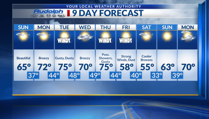
Sunday will be beautiful, though, with mostly sunny skies and a high near average around 65. Overnight temperatures will be cool with lows in the upper 30s and winds will be calm.
Come Monday, those calm winds increase somewhat as temperatures rise. A high in the low 70s is expected along with a low near 44.
Cue Tuesday, where we will see another stretch of breezy and windy conditions return. Expect a high near 75 with a low around 48. Winds will range from 20-25 mph, with gusts near 30 mph. Blowing dust is expected.
Wednesday will be similar with gusts anticipated to be in the 30-mph range. A slightly cooler high of 70 will be present along with a low near 49.
Thursday will be quite active as well. We will see a high in the mid-70s, strong winds and blowing dust. In addition, a chance of rain showers will be possible in the evening.
Friday is another windy day. Blowing dust will be present with strong gusts. Friday’s high is expected to be in the upper 50s to lower 60s.
At this moment, all the weather action seems to subside just in time for the weekend when a cool high of 55 is expected for Saturday with a slightly warmer Sunday.
 Read: Read More