


EL PASO, Texas (KTSM) — Happy Sunday, El Paso. I hope the time change treated you nicer than it did me – but I’ll take more sunlight any day so no complaints over here. We close out the weekend with clear skies and beautiful conditions, something that cannot be said for the days following Monday.
Multiple storm systems are headed our way, bringing with them plenty of strong winds and a chance for precipitation.
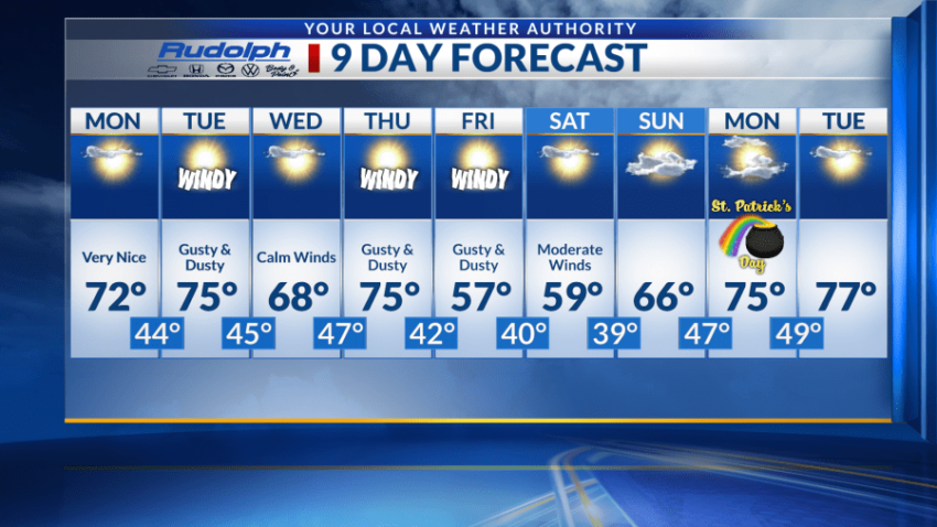
Monday will be very quiet with a high near 72 and a low around 44. Tuesday will start off beautifully, but come noontime expect those breezes to increase to mild winds falling just short of advisory level at 20-30 mph. These winds will be accompanied by a high near 75 and low around 45.
Wednesday, those winds settle on the breezier end with mostly sunny skies and a high around 68 and a low around 47.
Winds increase once again for Thursday, with a system blowing in cooler air and chances for precipitation. Blowing dust is a strong possibility. The high will be near 75 with a low around 42. Currently, there is a 40% chance for showers, mainly after midnight.
We see the cooler temperatures appear on Friday. This will be the coldest day of our 9-day period with a high near 57 and low around 40. Blowing dust in some areas is likely, but the chances are lower than what they are on Thursday. Similar conditions are expected for Saturday, with winds expected to decrease.
Come Sunday, conditions are expected to be warmer and calmer with a high near 66 and low around 47.
 Read: Read More