


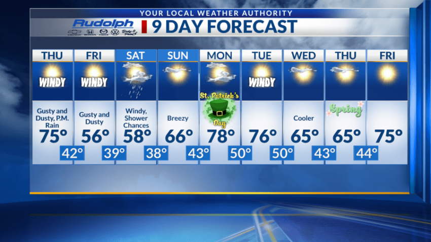
EL PASO, Texas (KTSM) — Brace yourselves, high winds and blowing dust are set to make a comeback Thursday afternoon through Friday.
The National Weather Service has issued three warnings for El Paso starting as early as noon on Thursday. A high wind warning, a blowing dust advisory and a red flag warning.
On Thursday, we’ll see a high near 75 and a low near 42. Winds will blow from the southwest at 25-30 mph during the day, with gusts near 40 mph. Overnight, winds will increase to 45-50 mph, gusts can reach speeds near 65 mph. If the winds weren’t enough, there is also an 80 percent chance of precipitation just before 3 a.m.
Warnings and advisories expire by Friday afternoon, but strong winds still remain. With a high around 56 and a low around 39, mostly sunny skies will be present, but conditions will be hazy with blowing dust. Winds will start near 45-50 mph in the morning and decrease to 30-35 mph by the afternoon, with gusts still potentially reaching speeds of 65 mph in some areas.
Saturday is just as active with a slight chance of rain and snow showers just before noon. Blowing dust in some areas is possible after noon time. Winds will be near 25-30 mph, with gusts as high as 40 mph. The high will be below average near 58 and low around 38.
Relief from the strong winds come Sunday, breezy conditions will be present along with a high near 66 and a low around 43.
For Monday, St. Patrick’s Day, we’re looking at a high near 80 with a low around 50. Conditions should be calm with light winds.
Tuesday will be windy again with a high in the upper 70s and low near 50. Wednesday and Thursday will be cooler with a high in the mid-60s, and lows in the lower 40s.
 Read: Read More