


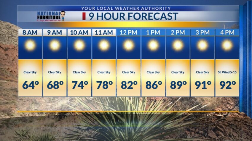
Welcome to the 90s! No, I’m not talking about the Backstreet Boys or CDs. I’m talking about our first day of the year that made it to 90 or above. The earliest El Paso ever hit 90 was March 18, 1907. We will be very close to or exceed the record high for the next three days. Here’s your exclusive 9-Hour Forecast for Friday:

TONIGHT: The skies will be clear, and the winds will be light out of the SE at 5-10 mph. The low will be a mild 59 at the airport, 54 in the valley.
FORECAST: Friday will be sunny and quite warm with a high of 92. High pressure reaches its maximum on Friday and Saturday, and warm temperatures will follow us into the weekend. We will be very close to the record Friday, which is 94 set in 2018. Saturday will be sunny and windy. The SW winds will gust near 30 mph, below the level to produce any blowing dust. Saturday will probably break the record of 90 set in 2018. Sunday will also be flirting with record heat. Sunday’s high will be 91, and the record is 92 set in 2018. Sunday will be sunny with moderate winds from the SW, which will gust near 35 mph. It should be just below the level needed for a dusty haze. Monday will be partly to mostly cloudy and cooler with a high of 86. Tuesday will be partly to mostly cloudy with a slight chance of isolated area t-storms (non-severe). Tuesday’s high: 88. Wednesday will be sunny with moderate winds. The SW winds will gust near 40 mph, which may produce a slight dusty haze. Wednesday’s high: 89. Thursday will be sunny and very warm with a high of 90.

Read: Read More