



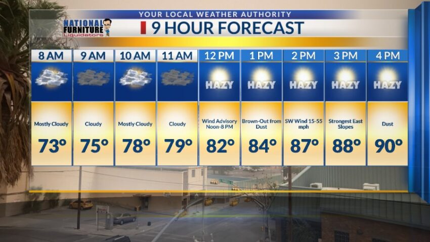
The winds have gusted over 60 mph at the airport today. Unfortunately, the upper level structure of the atmosphere stays nearly the same over the next six days with a powerful node of the jet stream sitting right on top of us. This will mean strong winds and dust for the next six days. Here’s your exclusive 9-Hour Forecast for Wednesday:

TONIGHT: A Dust Storm Warning is posted until 6:15 PM. This is the highest level of warning for dust with visibility under a mile in most areas. A Wind Advisory and a Blowing Dust Advisory are posted until 8 PM. The west winds will gust near 55 mph with stronger winds on the east slopes of the mountains. Late evening, the winds will diminish a bit, never fully dying down completely. The low will be 73.
FORECAST: KTSM has issued a Weather Authority Alert due to powerful winds and blowing dust for the next six days. Wednesday will bring another afternoon of strong winds and dust. A Wind Advisory is posted from noon until 8 PM. The SW winds will gust near 55 mph, and we could see a near brown-out from dust by the afternoon. Wednesday’s high: 90. Thursday will be a terrible weather day with strong winds and blowing dust. With a high of 89, the SW winds will gust near 60 mph. A brown-out of dust will be likely by afternoon. Friday will bring more strong winds and blowing dust. With a high of 88, the power of the winds will be enhanced by a fast-moving low-pressure system. Expect a near brown-out from dust by afternoon. Saturday will be sunny in the morning with strong winds and dust in the afternoon. West winds will gust near 50 mph, and the high will be 91. Sunday will be sunny with strong winds and dust and a high of 95.

Read: Read More