



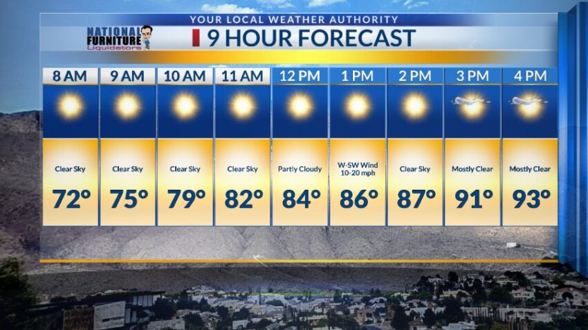
How many people were awakened by t-showers late last night or early this morning and immediately ran to the patio to see it??? Me!!! I was one! Oh, how wonderful to get some much needed rainfall. Officially, the airport recorded 0.02 inches, making the total for the year 0.52 inches. Normal this time of year is 1.65 inches, so we are way behind. Unfortunately, El Paso is in an Extreme Drought, which is the most severe classification for draught. The last year that we exceeded our normal rainfall for the year was 2021. Here’s your 9-Day Forecast for Tuesday:

Your full forecast is below, but please enjoy a few Weather Watcher pics of the rain first.


TONIGHT: The skies will be partly to mostly cloudy with a few isolated area showers that will taper offer during the evening. The skies will be partly cloudy to fair overnight. Expect moderate winds out of the west at 10-35 mph. The winds will slowly die down through the night, and the low will drop to 70.
FORECAST: Tuesday will be partly cloudy with warmer breezes and a high of 93. The west-SW winds will range from 10-20 mph. We could see a few showers/t-storms east of El Paso County and over the Sacramento Mountains, but El Paso should stay dry. Wednesday will be mostly sunny with a few clouds and a high of 99. Thursday will be sunny and hot with a high of 99. High pressure settles in for the weekend and will take temperatures into the extreme range. Friday will be sunny and 102. Saturday will be mostly sunny with a few clouds and 104. Sunday will bring extreme heat with a high of 105. Monday will also bring extreme heat with a high of 106.

Read: Read More