


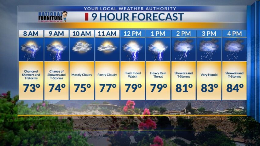
On a day like this, no one is more excited for rain than I am. And so far, I am disappointed. We could think, well, it hasn’t rained yet, so I guess the threat of heavy rain has passed. No, no, no! We have an extremely unstable atmosphere and tropical levels of moisture. That combination makes me nervous, and I am keeping the Weather Authority Alert in place through Wednesday night. Wednesday will bring the same chance of heavy rain with area t-showers, and here’s your exclusive 9 Hour Forecast:

TONIGHT: KTSM has issued a Weather Authority Alert due to the potential for heavy rainfall from area t-showers. A Flash Flood Watch is posted for the entire Borderland through Wednesday night. A surge of monsoon moisture from Mexico has increased the chance of storms. Individual storms may unlock heavy rainfall that could quickly flood streets and arroyos. Do not drive into flooded roadways. Expect overcast skies tonight, and the low will drop to 68. The SE winds will range from 5-15 mph.
FORECAST: Wednesday has an almost identical meteorological profile as Tuesday. An extremely high level of tropical moisture means we must not drop our guard against the chance of t-showers that bring heavy rainfall. That threat of heavy rainfall extends through Wednesday night. Wednesday’s high will be 84, and the east winds will range from 5-20 mph. Thursday will be partly cloudy and hotter with a high of 89. Expect scattered late day t-storms and t-showers. Friday will be partly cloudy and 92 with scattered late day showers and t-showers. We start to heat up again for the weekend ahead. Saturday will be 96 with isolated area t-storms. Sunday will be 99 with isolated area t-storms. Monday will be partly cloudy and 99 with isolated area t-storms.

Read: Read More