


EL PASO, Texas (KTSM) — Happy Saturday, Borderland! Monsoon season is in full swing, and there is more rain on the radar going into July.
Moving through the rest of the weekend, there are very slight chances for thunderstorms near the mountains in the evening hours.
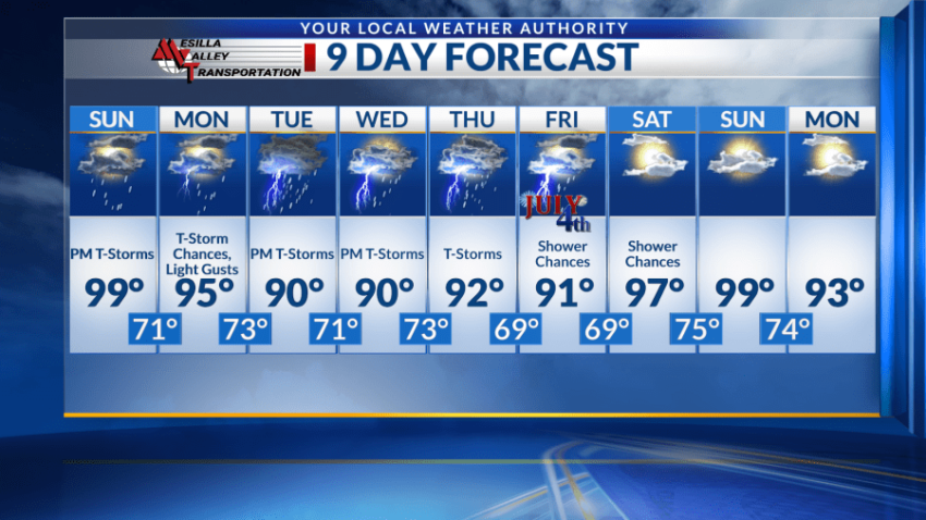
Saturday night, El Paso will see a low near 72 with calm winds coming from the southeast. Rain chances diminish as we move away from sunset into the late night, but moisture will remain.
Thunderstorms are still possible on Sunday but closer to the late afternoon and evening hours and will have less coverage. A high near 99 is expected with light winds throughout the day. Overnight, storm chances continue but will be primarily in the mountains. The low will be around 70.
Monday will be very similar to Sunday, only slightly cooler and a bit gustier. A high near 95 is expected with a low around 73.
Chances for thunderstorms in the afternoon increase on Tuesday and Wednesday. The highs will be near 90 with lows in the lower 70s. Rain chances increase Wednesday night and will have more coverage than previous days.
For Thursday, that moisture carries over. Chances increase even more for showers and thunderstorms, especially at night. The high will be around 92 with a low near 68.
On Fourth of July, the chance of precipitation begins to taper off again with slight chances for showers. The day will be mostly sunny with a high near 90 and a low around 69.
 Read: Read More