


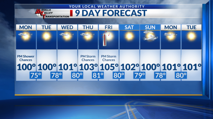
EL PASO, Texas (KTSM) — Happy Sunday, Borderland. Looking forward, we are tracking 9 days of above-average temperatures, potentially even seeing some digits that call for a heat advisory.
Starting off with Sunday night, isolated shower and thunderstorm chances remain into the evening and overnight hours. The low will be near 78 with winds blowing from the east, 5-10 mph. Gusts can reach speeds as high as 20 mph.
Monday will almost mirror Sunday’s conditions. Mostly sunny skies will be present with a high near 100. Slight showers and thunderstorms are possible, present with winds 5-10 mph through the later afternoon and into the early evening hours. Storm chances increase just before midnight with a low in the mid-70s. Winds will blow at 5-10 mph.
Come Tuesday, moisture levels will drop off as temperatures begin to increase. Another day of low triple-digit temperatures is on the board with sunny skies. The low will also be above average, in the low 80s coupled with light winds.
Wednesday through Friday, El Paso will see a steady increase in temperatures potentially reaching above 105. Slight storm chances will return for the evening hours Thursday and Friday and the lows through this period will be in the upper 70s and lower 80s.
This week will be very hot and sunny. Be sure to stay hydrated throughout the day and avoid being outdoors during peak heat if possible.
 Read: Read More