


It has been a busy afternoon for storms and rain. Here is a capture of the radar this afternoon indicating a Severe Thunderstorm Warning that expired at 5 PM. Flood Advisories over Fort Bliss and central El Paso expire at 6:30 PM. Do not drive into flooded roadways.

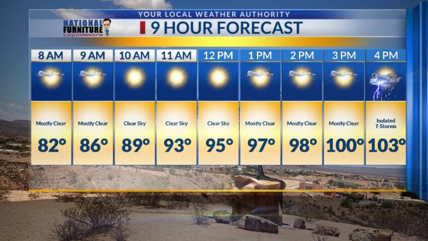
We are in for a big change with a return of Extreme Heat. Here’s your exclusive 9-Hour Forecast for Tuesday:

TONIGHT: The skies will be partly to mostly cloudy with widely scattered showers and t-showers. Some individual storms may produce brief, locally heavy rain. The SE winds will range from 5-15 mph with occasional gusts as area storms break apart. The low will drop to 75, and the skies will slowly clear overnight.
FORECAST: Tuesday will begin our warming trend that will take us up to extreme heat level by Wednesday. Tuesday will be partly cloudy with a high of 103 as a giant dome of high pressure builds up over the Borderland. We’ll have a chance of isolated (hit-or-miss) late day t-storms, but the chance of rain goes down on Tuesday. The SE winds will range from 5-20 mph. On Wednesday and Thursday, the chance of an isolated area storm will be only very, very slight. Wednesday will be partly cloudy with a high of 106. Thursday should be the hottest day of the week with a high of 107. The SE winds will range from 5-20 mph. Friday will be partly cloudy and 105 with a slightly better chance of late day t-storms. Saturday will be partly cloudy with widely scattered showers and t-showers with a high of 102. By Sunday, the ridge of high pressure breaks down giving us a very good chance of storms and heavy rainfall.

Read: Read More