


You could feel the difference in humidity this morning. Those thick stratus clouds were so pleasant, but they cleared just long enough to get us up to 97 today. That set off the t-showers that, as expected, produced brief, heavy rainfall. Below is the Flood Advisory posted for central El Paso.

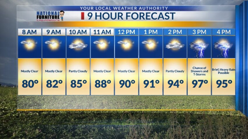
We have a similar moisture profile for Friday, so get ready for more t-showers. Here’s your exclusive 9-Hour Forecast for Friday:

TONIGHT: Moisture levels have jumped up significantly today, so expect widely scattered showers and t-showers with the potential for brief, heavy rainfall. Some individual storms may cause localized flooding of arroyos and streets. The t-showers will slowly taper off late evening. The skies will then be partly cloudy, and the low will drop to 75.
FORECAST: Friday will be partly cloudy and 97 with scattered late day t-showers. Brief, heavy rainfall will be possible on Friday as well. A ridge of high pressure builds back for the weekend. Saturday will be hot and partly cloudy with a high of 100. Sunday will be partly cloudy with a high of 101 and a slight chance of isolated late day t-storms. Monday will be partly cloudy and 100 with a better chance of late day t-showers. Tuesday will be partly cloudy and 96 with widely scattered showers and t-showers. Brief, heavy rain out of some storms will be possible both Tuesday and Wednesday. Wednesday will be partly cloudy with widely scattered showers and t-showers. Wednesday’s high: 95.

Read: Read More