


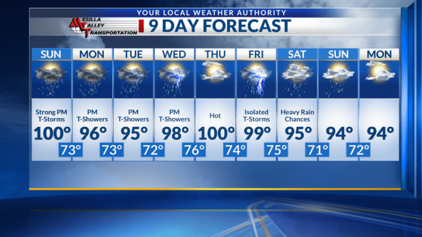
EL PASO, Texas (KTSM) — Happy Saturday, Borderland. The region is looking at hot temperatures for the remainder of the weekend with an addition of moisture into the equation.
Beginning with Saturday night: A low around 75 with a chance of showers and thunderstorms around 11 p.m. Winds will blow around 5-10 mph from the southwest and become more northwest after midnight.
Sunday’s high will remain in the triple-digits range around 100. Shower and thunderstorm chances are present mainly after 4 p.m. along with mostly sunny skies. Winds will be calm throughout the day. Overnight, mostly cloudy skies with a low around 73. Showers and thunderstorms are possible mainly before midnight.
Throughout the daytime Monday, shower and storms chances are slight but grow closer to the later evening hours. Mostly sunny skies will be present along with a high around 96. Winds will be light and variable. Low will be in the lower 70s.
Tuesday and Wednesday will be very similar precipitation-wise. Shower and thunderstorm chances will be greater in the evening. Highs will be in the upper 90s range, with lows in the lower to mid-70s.
Thursday offers a bit of relief from the moisture as the region dries out and returns to the 100s.
Come Friday through the weekend storm chances are on the radar again with high temperatures closer to average in the mid-to-upper 90s.
 Read: Read More