


EL PASO, Texas (KTSM) — Happy Saturday, Borderland. We felt the humidity, saw the clouds, but alas, no storms coming to fruition. You can blame the lack of instability and lift in the atmosphere for that.
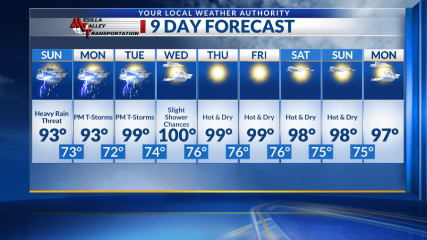
Thunderstorms require a recipe of three things, and unfortunately for those that love the rain, we only had moisture for today. Chances for storms continue into Sunday, however, and there is also the chance for evening showers and storms through Wednesday.
Even for Saturday night, don’t count out the possibility of scattered showers potentially around midnight. Skies will be mostly cloudy with a low around 73. Winds will be calm, blowing from the southwest around 5 mph.
For Sunday, we will have a similar start to the day with a mostly cloudy morning that will eventually turn mostly sunny as we go into the afternoon. The high will be near 93 with possible shower chances starting in the late afternoon. The storm and shower chances grow the closer it gets to evening with light and variable winds after midnight. The low will be in the lower 70s.
Moisture sticks around Monday and Tuesday, with high temperatures in the mid- to upper 90s. Shower and storm chances are present in the evening with lows in the low to mid-70s.
Conditions begin to dry out Wednesday, giving the region one more shot at seeing storms from the afternoon to evening. These chances are slight but you can’t rule it out just yet. Temperatures will be warmer with a high near 100 and mostly sunny skies.
Hot and dry conditions will persist Thursday forward with sunny skies and highs in the mid- to upper 90s. Lows will be close to the mid 70s.
 Read: Read More