


Our monsoon took a quick trip to Arizona last weekend, but now it’s back and ready to give us rain chances again. For example, we’ve had some isolated, hit-or-miss thunderstorms, such as the one that formed over Berino this afternoon. We’ll have a much better chance of more widely scattered t-showers on Wednesday. Here’s your exclusive 9-Hour Forecast for Wednesday and your 9-Day Forecast below.


TONIGHT: The skies will be partly cloudy with isolated area t-storms early in the evening. Individual storms may produce some brief rainfall. We could experience occasional gusts as area storms break apart. Overnight, the skies will clear, and the SE winds will range from 5-15 mph. The low will drop to 72.
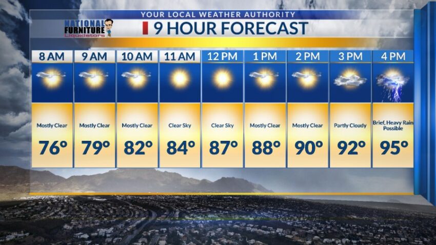
FORECAST: Wednesday will be partly cloudy with widely scattered showers and t-showers. The storms will be more widely scattered on Wednesday, and brief, heavy rain out of some storms is likely. The SW winds will range from 5-15 mph, and the high will be 95. Thursday will be partly cloudy with only a slight chance of isolated PM t-storms. Thursday’s high goes up to 98 due to a build-up of high pressure. Friday will be partly cloudy with isolated PM t-storms. Friday’s high: 98. Saturday will be partly cloudy with widely scattered showers and t-showers. Some storms may become strong and produce brief, heavy rain. Saturday’s high: 96. Sunday will be a very unstable day for the atmosphere, meaning we could see some of the strongest storms of the week on Sunday. Some may produce brief, heavy rainfall as well. Look for partly to mostly cloudy skies with a high of 92.

Read: Read More