


EL PASO, Texas (KTSM) — A weather alert has been issued due to the showers and storms that will hit a good portion of the Borderland region starting Saturday afternoon running through Monday night.
In El Paso, storms are anticipated to begin later Saturday evening, hitting west before migrating eastward. Overnight, the skies will be mostly cloudy coupled with a low near 67. Winds will blow 5-10 mph with rainfall amounts potentially registering between a quarter to half of an inch.
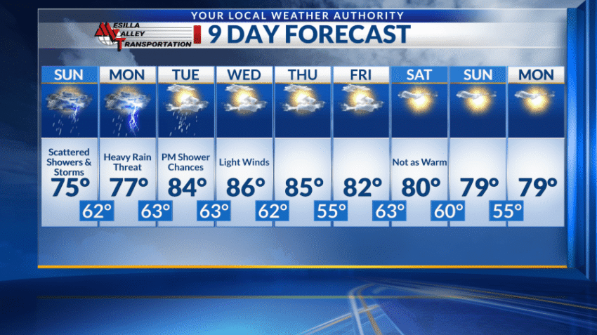
Shower and thunderstorm chances continue Sunday, starting in the afternoon and running through the night. The high will be cooler, around 75 with winds blowing 5-10 mph. Overnight storm chances persist with a low in the lower 60s.
On Monday, the high will still be below average in the mid- to upper 70s. Winds will be light for the most part but heavy rain will remain a threat with showers and storms expected to begin early in the afternoon and lasting until the evening. The overnight low will be in the low 60s.
Chances for showers decrease by Tuesday, but evening storms are still a slight possibility. The high will be around 85 with a low near 65.
Wednesday will see light winds with mostly sunny skies and a high in the mid 80s. Overnight lows will be around the lower 60s.
Thursday forward, temperatures will slightly decrease to below average as we inch closer to the weekend and as of this forecast, skies will be mostly sunny.
 Read: Read More