



by Tim Holt
Chris Fox used to be somebody in El Paso. In fact, the Vice President of the biggest bank in town was often referred to as “Mr. El Paso” for his civic pride, philanthropy, and promotion of our Sun City. Of course, that was a long time ago in a dust storm far, far away. He went to El Paso High, was sheriff for a while, and eventually became the Vice President of the State National Bank, back in the days when one could go from being El Paso County Sheriff to a bank vice president and no one said a thing. He died in 1984 and everyone cried. Mr. El Paso had gone to meet the great Amigo Man in the sky. We have never had a new “Mr. El Paso.” “Mr. Durangito” maybe. But no one cares.
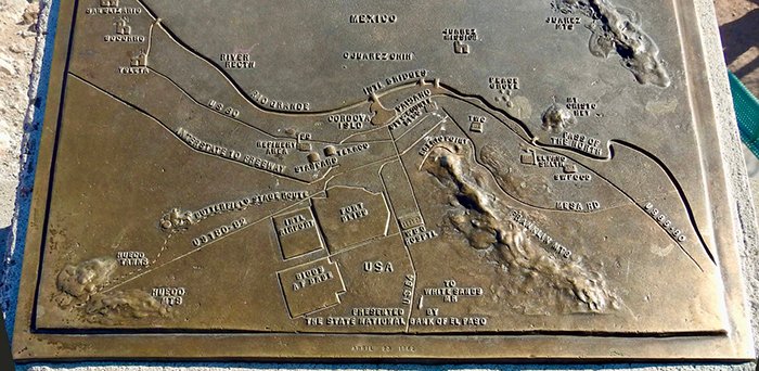
Somewhere along the way, in the early 1960s, Mr. El Paso, now Vice President of Southwest National Bank, had lots of friends and a load of advertising cash he could use to promote El Paso. He decided that installing plaques along Scenic Drive would be a great way to show tourists what exactly they were looking at. Also, each plaque would advertise Southwest National Bank and be dedicated to some aspect of the region. So, he designed them, hired artists, and donated a bunch of bronze plaques to the city. The city installed them up at the top of Scenic Drive, and everyone was happy. Another win for Mr. El Paso.

But much like Buddy Hackett jokes on The Tonight Show with Johnny Carson, the plaques, as they say, have not aged well. Unlike most true historical markers, that say something like “Billy the Kid ate dinner here, rented out an entire brothel, and broke out of jail on this date in 1878,” the plaques that Fox had donated were meant to point out actual things that people could see, or at least pretend to see, from the Scenic Drive overlook in the early 1960s. See that water over there? That’s the Rio Grande. See that cross on a mountain over there? That’s Mt. Cristo Rey. If you squint real hard, you can see the San Elizario Chapel. The plaques, for the most part, were made for their time. And that was it. They only “worked” if you were looking at them in the 1960s.
Perhaps there was a plan to periodically replace them. Perhaps Mr. El Paso had donated extra cash to make new ones and the cashbox got lost when they tore down the old Liberty Hall. Who knows? The point is, the plaques from the 1960s are still there, and they, for the most part, are close to being almost completely wrong.
Haven’t seen them lately? Here are just a few of the gems that are on these plaques that you can go see TODAY (assuming that Scenic Drive hasn’t collapsed in the latest rainstorm):
Cordova Island
El Paso Smelting Works
Biggs Air Force Base
Texas Western College
William Beaumont General Hospital
Peace Grove
The Portland Cement Factory
The entire Gadsden Purchase
Phelps Dodge Copper Refinery (home of the largest electrolytic refining in America!)
Standard and Texaco Oil refineries
Hart’s Mill (right across the river from Peace Grove near Texas Western College)

If you were looking at these plaques, you would learn such interesting “Facts” as:
Interstate 10 stops dead, right at Bassett Shopping Center.
El Paso’s population of 276,867
El Paso International Airport is one of the busiest in the entire country.
A giant star is lit every Christmas to shed its light on the “grateful people of El Paso and Juarez.”
Learn all about the famous “Rio Grande Rectification Project,” which sounds more like a ’70s prog-rock band or a lower GI tract procedure than a political agreement.
The monument to the Salt Wars can be seen from the “Lower Valley Missions,” even though it is about 75 miles away in Hudspeth County.
El Paso and Juarez have a combined population of just under 600,000!
Now granted, some of the things listed have just been renamed over the years and are still around, but using the information on those plaques is like using a Windows XP manual to try and figure out your Windows 11 computer.

Most businesses highlighted here were also I suspect, the clients or friends of the State National Bank of El Paso, Texas—Mr. El Paso, Chris Fox, president. Many, if not most, just like the State National Bank itself, are no longer in existance.

Add the weird monument in Upper Tom Lea Park (again purchased by the State National Bank, bearing a plaque that erroneously labels the Franklin Mountains as the southernmost tip of the Rocky Mountains (a marketing tactic devised by the “Women’s Deprtment of the Chamber of Commerce” at the time before we became the Mexican Food Capitol of the World or whatever Visit El Paso is calling us this week), and you encounter roughly a mile of misinformation that I would guess is unmatched by any major Texas city. Misinformation Mile anyone? Our newest tourist attraction! Has a nice ring to it.
Who cares, you might ask? Well, consider this: Scenic Drive, and its overlook, is a major destination for tourists in our fair city. First impressions are important, and a bunch of people that might not know better—people unfamiliar with the city—are getting their first impressions of our city up on Scenic Drive.
“Oooh, Inga, look, can you see da Rectification Project?”
“Is it near that big red X Sven?”
“How about the Peace Grove?”
“Is it near da Cordova island or that WestStar Tower?”
Yes, the plaques say “Presented in 1963” or something like that, but they are presented as historical monuments, not as “Here is what we used to look like.” I know the difference is subtle, but I have actually been on Scenic Drive where people are looking at the plaques then staring off into the distance trying to locate what is on it. Sven and Inga drove away confused.
Some might say that the plaques are “historical,” but they are only historical in the fact that they are old. If that is the case, I am just as historical as they are, having been born before the first plaque was ever installed. There is one plaque that has a map drawn by Jose Cisneros, so it might indeed have some historical and artistic value, but all the rest need to be packed up and sent to the El Paso Museum of Art or History , where they can sit in a warehouse with the rest of their collections. (See “Yes You Own It, No You Can’t See It:” https://elchuqueno.com/yes-you-own-it-no-you-cant-see-it/ )
There have been plans to redo the Murchison / Rogers overlook park since 2017 (https://surroundings.studio/murchison) but like the plaques, no one seems to want to actually move on it. The plan itself, almost a decade old, is becoming historical much like the plaques.
In the meantime, the misinformation continues.
Chris Fox, it seemed, was trying to explain El Paso to people who didn’t know it. That was a good idea in 1963 and it is still a pretty good idea today. We just need to update the explanation sooner than every sixty years or so with actual useful information that is relavent and not subject to the whims of time. Give visitors the Rio Grande. Give them the geology. Explain why two cities in two countries grew together in the Pass of the North. Explain the Franklin Mountains. Explain Juárez. Explain the desert. And maybe keep some of the old plaques on display at the History Museum so visitors can see what Mr. El Paso wanted them to see in 1963.
I bet Mr. El Paso would be proud if we did that.
Read: Read More