


EL PASO, Texas (KTSM) — It is Sunday and a very lovely day, feeling like spring. With that being said, it’s time to burst that bubble because the Borderland is expecting to see gusts and rain through out the week ahead.
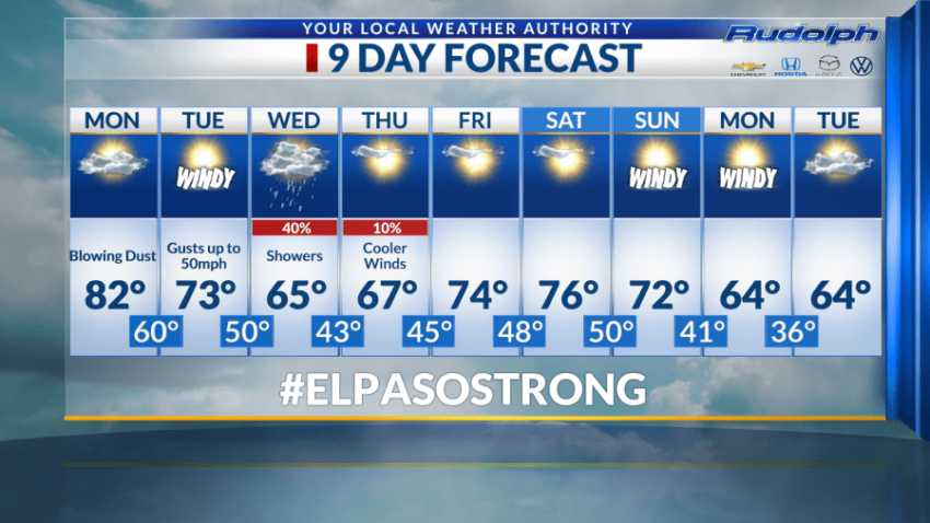
Anyways looking at that detailed forecast, Monday is forecasted to be paired with breezy conditions, blowing dust with the high of the day to sit at 82 degrees. Our overnight low cools off to 60 degrees.
Tuesday is when it gets spicy. Temperatures for the day are expected to cool off to 73 degrees along with windy conditions ranging from 25-35 mph and gusts up to 50 mph. Yikes! The overnight low for the day is predicted to be 50 degrees.
Happy Wednesday, with the workweek almost done for most of us. We are forecasting the high of 65 degrees paired with 40% chance of rain showers in the afternoon lingering into the evening while the overnight low sitting at 43 degrees.
We are forecasting cooler winds on Thursday and 10% chance of rain in the morning from those lingering rain chances from the day before. We are forecasting the high on Thursday to be 67 degrees with an overnight low of 45.
Friday skies clear up and the high is predicted to warm up to 74 degrees and dropping to 48 degrees in the night.
The remainder of the week with be in the lower and mid-70s and 60s paired with windy conditions with the overnight low jumping around from the 50s, 40s and 30s. What a rollercoaster!
Hang in there El Paso. We are just 23 days away from Spring!
Read: Read More