



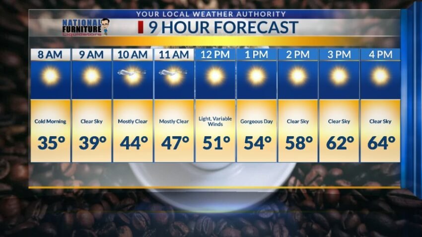
What a nasty day!! With a peak gust at the airport of 40 mph, today’s stronger winds really stirred up the dust. The official high was 53 for today, 8 degrees below normal. The good news is that we are in for the most beautiful weekend! Here’s your exclusive 9-Hour Forecast for Friday and your detailed 9-Day Forecast below.

TONIGHT: A Blowing Dust Advisory is posted until 6 PM. Visibility is down to under 1 mile in some areas, so exercise caution while driving. Slowly, the strong, gusty winds and blowing dust will settle down through the evening hours. Until then, the W-NW winds will range from 15-40 mph with the strongest gusts on the east slopes of the mountains. Once the winds settle down, we’ll drop to a chilly 28 at the airport.
FORECAST: Friday will be sunny with light winds and a high of 64. The variable winds will range from 5-10 mph… a truly beautiful day. Saturday will be mostly sunny with a few clouds and a high of 70. Sunday will be mostly sunny with moderate afternoon winds. The SW winds will range from 10-25 mph. High pressure ensures a very warm workweek with possible record temperatures. Monday will be sunny and 78. Tuesday will be mostly sunny and 78. Wednesday will be mostly sunny with moderate winds and a high of 76. Cooler winds blow in on Thursday, dropping the high to 70.

Read: Read More