


Happy Friday, everyone. Did you enjoy this freezing cold day in the middle of winter? Brutal, right? Yes, it was another record today. The official high is 81, and that broke the old record of 79 set in 2009. This is our fifth record of the week!

TONIGHT: The skies will be clear, and the winds will be breezy to windy at times on the east slopes. The west winds will range from 10-25 mph with occasional gusts on the east slopes. The winds will slowly die down early evening. The low will drop to 45 at the airport, 40 in the valley.
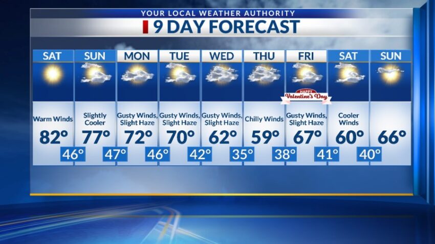
FORECAST: Saturday will be sunny with record warmth and a high of 82. The SW winds will range from 10-20 mph (no dust). Sunday will be partly cloudy with slightly cooler breezes. The SW winds will range from 5-20 mph. The big zone of high pressure starts to break down on Sunday, so the high will be 77, just shy of the record of 78. Monday will be partly to mostly cloudy and very windy. The high will drop to 72, and the SW-west winds will gust to near 40 mph. This will be the first day of a very windy week with a dusty haze in the afternoon. Tuesday will be partly to mostly cloudy with gusty winds and slight dusty haze by afternoon. Tuesday’s high: 70. Wednesday will remind us it is still winter with a high of 62. Look for partly cloudy skies with chilly winds. Thursday should be the coldest day with a high of 59 under mostly cloudy skies. Valentine’s Day will be partly cloudy and windy with a high of 67.

Read: Read More