


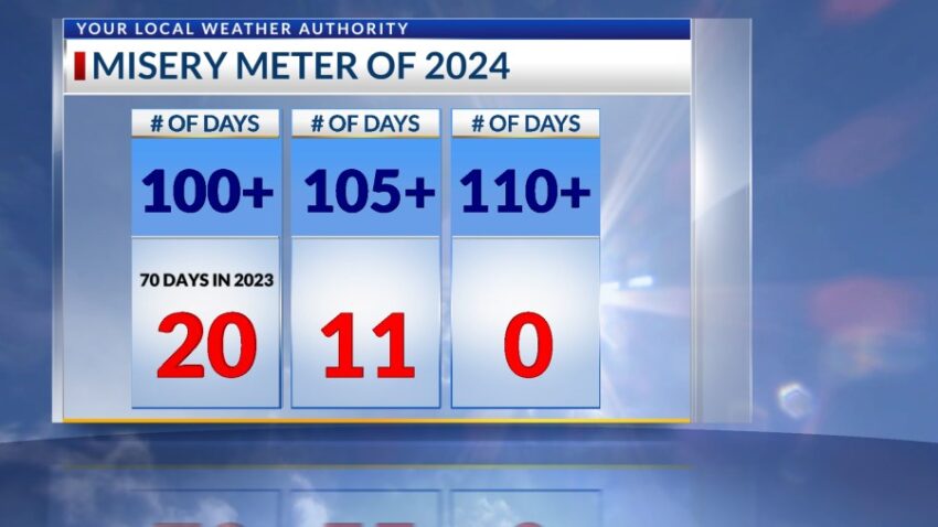
A Heat Advisory extends through Saturday. We added to the “Misery Meter” today with out 20th day of triple-digit heat. Eleven of those days have been 105 or hotter. The official high is 103 today, and the record is 113 set in 1994.
TONIGHT: The skies will be partly cloudy early evening buy turn clear overnight. The atmosphere is very stable, so we only have a slight chance of an isolated area t-storm forming in the area. Rain chances are near zero. The NW winds will range from 5-10 mph, and the low will drop to 80.
FORECAST: A Heat Advisory is in effect through Saturday. Saturday will be partly cloudy and hotter with a high of 106. Expect isolated area t-storms forming from the heat. Rain chances are low, but individual t-storms may produce some brief rainfall. The SW winds will range from 5-15 mph. Sunday will be partly cloudy and a little cooler with a high of 100. The east winds will usher in some slightly cooler air. We’ll have only a slight chance of isolated area storms with an almost zero rain chance on Sunday. Monday will be partly cloudy and dry with a high of 104. Tuesday will be partly cloudy with a high of 103. Expect isolated area storms with a low rain chance on Tuesday evening. Wednesday will be partly cloudy and 103 with widely scattered t-showers. Some of the storms may become strong on Wednesday with the threat of heavy rainfall. The Fourth of July will be partly cloudy and fairly humid with a high of 98. Expect widely scattered t-showers to go with the fireworks.
Read: Read More