


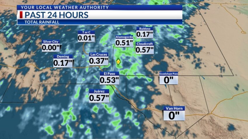
Take a look at the 24-hour rain totals!! Officially at the airport, we’ve received 0.39 inches today for a total for the year of 3.44 inches. Normal this time of year is 5.42 inches, but we’re starting to close the gap. Expect an entire week of t-showers with more rain likely.
TONIGHT: The skies will be partly to mostly cloudy with widely scattered showers and t-showers. Some individual storms may produce locally heavy rainfall, so please do not drive into flooded roadways. The NE winds will range from 5-15 mph, and the low will drop to 70.
FORECAST: Wednesday will be partly to mostly cloudy with widely scattered showers and t-showers. Some individual storms may produce locally heavy rainfall. The high will be 91, and the SE winds will range from 5-15 mph. Humidity levels will be high for Borderland standards for the rest of the week. Thursday will be partly to mostly cloudy and 94. We’ll experience widely scattered showers and t-showers Thursday PM. Friday will be partly cloudy with a high of 94 and widely scattered showers and t-showers. On Saturday, the winds turn NE at 10-30 mph as cooler air moves in. Saturday will be 89 with mostly cloudy skies and scattered t-showers. Sunday will be partly to mostly cloudy with a few showers here and there and a high of 85. Labor Day Monday will also be cool with a high of 85 and a chance of a few showers here and there.
Read: Read More