


The official high today is 99. We can thank the additional midday cloud cover for suppressing the day’s heating. The record on this date is 106 set in 2020. It’s been so hot lately that I think we’ve all be trying to find “cool” things to do inside. Monica Cortez took “coolness” to a whole new level with a birthday party for her dog Chilaquils. “Ruff, woof!” That’s how you say “Happy Birthday” in canine.
TONIGHT: The skies will be partly to mostly cloudy with widely scattered showers and t-showers. Some individual storms may produce brief, heavy rainfall. The S winds will range from 5-15 mph, excluding gusts near area storms. The storms will taper off overnight, and the low will drop to 76.
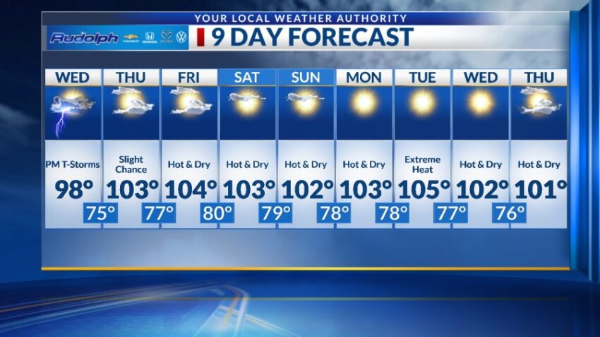
FORECAST: Wednesday will be partly to mostly cloudy and 98 with widely scattered late day t-storms. Though each storm could bring brief rainfall, the overall rain chances start to go down on Wednesday. The SW winds will range from 5-15 mph. A giant ridge of high pressure settles in for several days. Thursday will be partly cloudy and hotter with a high of 103. The chance of storms goes down to only a slight chance of isolated area t-storms. Friday will be partly cloudy and hotter with a high of 104. Saturday will be mostly sunny and 103. Sunday will be mostly sunny and 102. Monday will be sunny and dry with a high of 103. Tuesday should be the hottest day with sunshine and a high of 105.
Read: Read More