


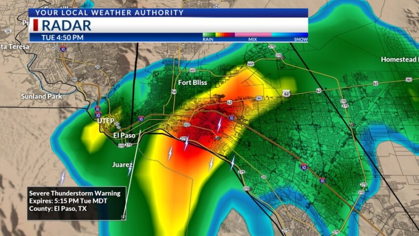
Many streets are still flooded, especially along the frontage roads of I-10 near Geronimo. Below is a snapshot of the radar at 4:50 PM, when a Severe T-Storm Warning was in effect. Some areas of central El Paso received close to 2 inches of rain in under an hour. Up in Ruidoso, the Ruidoso River went from 2 feet to 15 feet in just two hours. A flood and evacuation emergency has been activated in Ruidoso.

The worst of the rainfall has already fallen (for now), but we’ll keep watch for additional even t-showers. Mid-level moisture begins to thin out for Wednesday with only a slight chance of isolated late day storms. Here’s your 9-Hour Forecast for Wednesday:

TONIGHT: The skies will be partly to mostly cloudy with widely scattered showers and t-showers. Some individual storms may produce brief, locally heavy rain. The SE winds will range from 5-15 mph with occasional gusts as area storms move through and break apart. The low will drop to 75, and the skies will slowly clear overnight.
FORECAST: High pressure builds up for Wednesday. This will reduce the chance of storms and raise the high temperature significantly. With a high of 103, Wednesday will be partly cloudy with hot afternoon breezes. The SE winds will range from 5-20 mph. We will face extreme heat on both Thursday and Friday as high pressure grows to its maximum. Thursday will be partly cloudy with a high of 106. Friday will also be partly cloudy with a high of 106. We’ll have a very slight chance of late day storms on Friday. Saturday will be partly cloudy with widely scattered showers and t-showers with a high of 98. Sunday will be partly cloudy with widely scattered showers and t-showers and the threat of heavy rainfall. Sunday’s high: 96. Monday will be partly to mostly cloudy with widely scattered t-showers and the threat of heavy rainfall. Monday’s high: 93.

Read: Read More