



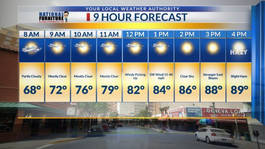
Much like today, Friday morning will be lovely. It won’t be until the afternoon that the winds get going. Enjoy Friday because, even though we may see a slight dusty haze, it will be a lot better than Saturday. Here’s your exclusive 9-Hour Forecast for Friday:

TONIGHT: The skies will be hazy with dust early in the evening. The strongest winds of the day will hit between 4 PM and 8 PM. The west winds will gust near 45 mph, with the strongest gusts on the east slopes. Slowly, the winds will die down through the night, and the low will drop to 65.
FORECAST: KTSM has issued a Weather Authority Alert due to powerful winds and blowing dust Saturday through Monday. Friday will be much like Thursday with a gorgeous morning and a windy afternoon. With a high of 89, the SW-west winds will pick up and gust near 40 mph. This will stir up a slight dusty haze by late afternoon. Saturday will bring a return of very strong winds and blowing dusty with a fast-moving low-pressure system.. The SW-W winds will gust near 55 mph, causing a near brown-out of dust by afternoon. Saturday’s high: 91. Sunday will be gusty and dusty with peak gusts near 60 mph. This will cause a dusty haze by late afternoon. Sunday’s high: 93. Monday will bring the strongest winds of the last 7 days with peak gusts approaching 70 mph. A powerful low-pressure system sweeps through the Borderland, and the winds will cause a brown-out from dust by the afternoon. Monday’s high: 87. Tuesday will be sunny and beautiful with light winds.

Read: Read More