


EL PASO, Texas (KTSM) — Hello, El Paso!
Have you seen the 2024 Paris Olympics yet? If not, you have some catching up to do.
Lady Gaga really set the tone for this year’s Olympics at the Opening Ceremony. I can’t wait to see what else is in store!
Let’s get back to our weather talk before I get carried away.
The National Weather Service has issued an air quality warning for El Paso. The warning is expected to expire at 3 p.m. Sunday.
The milky skies we have been seeing for the past few days come from producing high levels of ozone pollutants, like cars.
You can help prevent ozone pollution by carpooling with a friend, walking or riding a bike.
We can expect those milky skies to go away with strong winds or rainfall which we are forecasting for Saturday night.
Now, that we are on the topic of moisture. We are forecasting 40% chance of thundershowers Saturday. Our overnight is expected to drop to 77 degrees. Thundershowers are expected to subside right after midnight.
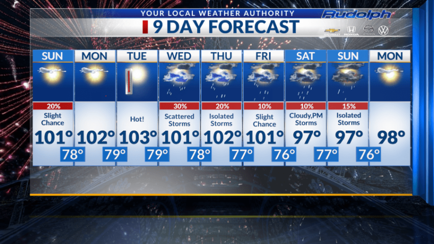
Monday, we are predicting a day of sunny skies paired with a high of 101 degrees. Humidity may stick around from Saturday’s rain, but it won’t be too jarring. Monday’s temperature cools off to 75 degrees.
It’s getting hot!
The high for Tuesday is forecasted to warm up to 103 degrees.
It is critical to stay hydrated on these hot days along with wearing sunscreen, light clothing and taking frequent breaks if you are outdoors for long periods of times.
Luckily, another moisture pattern makes it way to the Borderland, starting Wednesday.
We are likely to see 30% chance of scattered storms beginning Wednesday afternoon. The high is forecasted to reach 101 degrees. Overnight low dips to 78 degrees.
Isolated storms are in our forecast for Thursday with a high of 101 degrees.
Those storms will remain minimal. Storm chances start in the afternoon, possibly bleeding into Thursday evening. Our overnight low sits at 77 degrees paired with light winds.
Friday, we are expecting a 10% chance of storms. We are still on that triple-digit streak as we expect to reach 101 for our high.
Saturday is forecasted to bring us cloudy skies with a high of 97 degrees. Weather conditions change in the evening, with a10% chance of storms. Our evening low is 77 degrees.
Sunday’s high matches up with Saturday at 97 degrees. The day will consist of isolated storms. Now, these can start in the morning but those chances remain slim.
To top off your 9-Day Forecast, Monday is forecasted to be sunny and warm.
Enjoy the Olympics, El Paso!
Read: Read More