


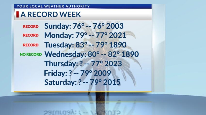
I thought today might be the one day we did NOT hit a record because the record today is 82 set in 1890. Our official high is 80, so our little streak of record temperatures was broken today. That said, we were a full 18 degrees above normal. Here are the record highs for the rest of the week, and, as you can see, we are on track for three more!

TONIGHT: The skies will be clear, and the winds will be breezy to windy at times on the east slopes. The west winds will range from 5-25 mph with occasional gusts on the east slopes. The winds will slowly die down through the night. The low will drop to 43 at the airport, 39 in the valley.
FORECAST: Thursday will be sunny and 79 with warm breezes. The SW winds will range from 5-20 mph. Friday will be sunny with warm winds gusting to near 20 mph (no dust). Friday’s high: 80. Saturday will be sunny with record warmth and a high of 80. The SW winds will range from 5-15 mph. Sunday will be mostly sunny with moderate winds in the afternoon. With a high of 75, the SW-west winds will range from 10-25 mph. Monday will be mostly sunny with very gusty winds and a high of 70. We could see a slight dusty haze by Monday afternoon. Tuesday will be partly to mostly cloudy with gusty winds and slight dusty haze by afternoon. Tuesday’s high: 65. Wednesday will remind us it is still winter with a high of 59. Look for partly cloudy skies with chilly breezes.

Read: Read More