


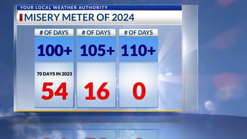
Sunday may be the last time we add to the Misery Meter this year. Sunday’s high was 101, but the high today was only 98!! The ridge of high pressure is gone, and the monsoon moisture has returned. That means much cooler days this week. We ended up with 54 triple-digit days, which is 16 fewer than last year’s 70 days.
TONIGHT: The skies will be partly to mostly cloudy with widely scattered showers and t-showers. Some individual storms may produce locally heavy rainfall, so please do not drive into flooded roadways. The SE winds will range from 5-15 mph, and the low will drop to 71. Overnight, all storms will taper off.
FORECAST: Tuesday will be partly to mostly cloudy with a high of 93. Humidity levels will be high for Borderland standards, and we can expect some isolated area t-storms cropping up with the afternoon heating. The SE winds will range from 5-15 mph. Wednesday will be partly to mostly cloudy with a high of 92. Expect a few isolated area t-storms on Wednesday evening. Thursday will be partly cloudy and 94. We’ll experience widely scattered showers and t-showers Thursday PM. Friday will be partly cloudy and 95 with widely scattered showers and t-showers. On Saturday, the winds turn NE at 10-30 mph as a cool front moves in. Saturday will be 89 with mostly cloudy skies and a few showers.
Read: Read More