


I had just pulled up for our noon service at church when my phone alarm triggered. Another Dust Storm Warning!! Again, the Interstate between Las Cruces and Lordsburg is closed due to dangerous conditions. El Paso is experiencing its second brown-out from dust for the second time this week, and we are likely to have another brown-out from dust on Saturday. The change? Saturday will feel much colder as a cold front blows through. Here’s your exclusive 9-Hour Forecast:

TONIGHT: KTSM has issued a Weather Authority Alert due to powerful winds and blowing dust today and Saturday. A Wind Advisory is posted until 8 PM. A Dust Storm Warning is posted until 6:30 PM but may be extended. A Dust Storm Warning is the highest level of warning for dust with visibility in some place under 1/4 mile. Drive carefully. The SW winds will be strongest during the evening hours, will cause a brown-out of dust, and will gust near 65 mph. The low will be 55, and the winds will die down a bit during the overnight hours.
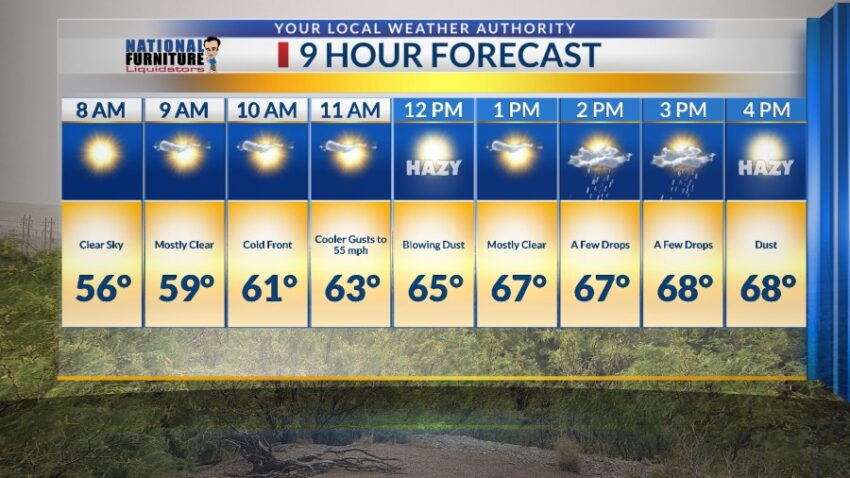
FORECAST: Saturday will be partly to mostly cloudy with much colder gusts. The SW winds will shift NW as a cold front comes through. Winds will gust near 55 mph, so yes, we will see blowing dust and a near brown-out by afternoon. Add in a chance of a few drops of rain for a real mess. Saturday’s high: 68. By Saturday evening, the winds will start to die down, and the dust will settle. After a horrible stretch of windy, dusty days, we can look forward to Easter Sunday. It will be gorgeous with sunshine, light winds, and a high of 77. Monday will be sunny and breezy with a high of 85. The SW winds will range from 5-20 mph. Tuesday will be sunny with moderate winds and a high of 87. The west winds will gust to 30 mph, but we should be dust free. Wednesday will be sunny and 86 with warm, moderate winds (no dust).

Read: Read More