


The warm, southwesterly winds popped us up to 76 today. That’s 5 degrees from the record of 81 set in 2016. Our peak wind gust at the airport was 33 mph, so we only saw a slight haze in the distance. That all changes tomorrow with stronger winds and dusty haze. Here’s your exclusive 9-Hour Forecast.

TONIGHT: The skies will be partly cloudy overnight, and the winds will be gusty. The SW-West winds will range from 15-35 mph with stronger gusts on the east slopes of the mountains. We’ll see a slight dusty haze by sunset, and the winds will diminish a little overnight. Expect winds to stay steady on the east slopes, and the low will be a mild 48.
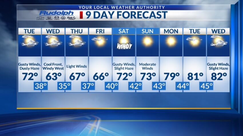
FORECAST: KTSM has issued a Weather Authority Alert for gusty winds and a dusty haze on Tuesday. The West-NW winds will range from 15-40 with the strongest gusts on the east slopes of the mountains. Tuesday’s high: 72. On Wednesday, a cool front blows in from the east, causing stronger gusts on the west slopes of the mountains. Wednesday will be partly cloudy, and the high will drop down to 63. Thursday will be partly cloudy with light winds and a high of 67. Friday will be mostly sunny with a high of 66. The winds will be light on Friday. Saturday will be mostly sunny but windy with a slight dusty haze by afternoon. Saturday’s high: 72. Sunday will be sunny with moderate winds and a high of 73. Monday will be sunny and 79 as high pressure builds up in a dramatic way.

Read: Read More