


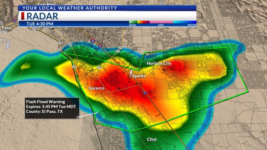
Tonight is exactly why I raised the Weather Authority Alert for the potential for very heavy rainfall. It will be a long night of potentially strong t-showers and the threat of heavy rain, and KTSM wants everyone to be safe. We have two active Flash Flood Warnings as of the posting of this story with more areas of heavy rain likely later tonight.


After the storms calm down tonight, I am dropping the Weather Authority Alert. Wednesday will be a very different day, and here’s your exclusive 9-Hour Forecast for Wednesday:

TONIGHT: KTSM has issued a Weather Authority Alert due to the potential for t-showers that could drop very heavy rainfall through tonight. Expect partly to mostly cloudy skies with widely scattered showers and t-showers during the evening and overnight hours. Some individual storms could unlock rapid, heavy rainfall flooding streets and arroyos. The SW winds will range from 5-20 mph with gusty winds likely near area storms. The low will drop to 69.
FORECAST: Wednesday will be partly cloudy and hotter with a high of 94. We dry out and stabilize on Wednesday as rain chances fade. We will only have the slightest chance of isolated area t-storms Wednesday evening. The SW winds will range from 5-20 mph. Thursday will be mostly sunny and 100 as high-pressure builds up over Texas. Friday will be mostly sunny with a high of 101. On Saturday, the monsoon moisture charges back up the t-storm chances for Saturday evening. Saturday’s high: 102. Sunday will be partly cloudy and 99 with widely scattered showers and t-showers. Monday will be cloudy with widely scattered showers and t-showers with the threat of heavy rainfall.

Read: Read More