


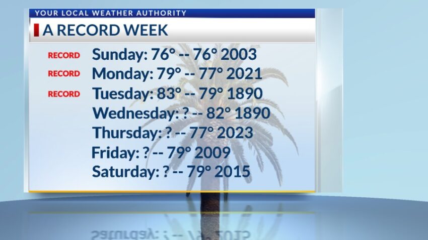
Our week of record high temperatures added yet another record today. Today’s high of 83 broke the old record of 79 set in 1890. We have the potential to tie or break a record every day through Saturday. Tomorrow, the record is 82 set in 1890. I am predicting 80 for Wednesday, but with strong enough winds, it may touch 82. Here are the remaining days of this week and their record highs.

TONIGHT: The skies will be mostly clear with just an occasional cloud. The SW breeze will range from 5-10 mph, and the low will drop to 46 at the airport, 40 in the valley.
FORECAST: Wednesday will be mostly sunny with slightly stronger winds. The SW winds will pick up and gust to near 20 mph (no dust). This will pop the high up to 80. The record for Wednesday is 82 set in 1890, so we should be just shy of the record. Thursday will be sunny and 79 with warm breezes. Friday will be sunny with warm winds gusting to near 20 mph (no dust). Friday’s high: 80. On Saturday, enjoy another potential record day with a high of 79. The SW winds will range from 5-15 mph. Cooler breezes filter in on Sunday, dropping the high to 74. Monday will be sunny with very gusty winds and a high of 70. Tuesday will be partly to mostly cloudy with a very slight chance of a few raindrops. Tuesday’s high: 65.

Read: Read More